多源在线与离线数据读取二(四川省地理信息中心切片读法)
分享
-
2013-09-13
四川地理中心在2011年,后台采用的是ArcGIS发布的Rest服务,但由于进行了Rest扩展开发,无法利用软件直接读取,所以这里给出相关的一些剖析及读取方法。
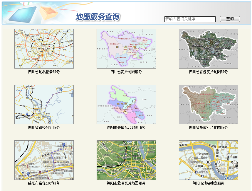
下面是四川地理信息中心能提供的一些服务,从类型上来讲包括切片、搜索及网络分析,均采用Rest组织风格。
下面针对切片的相关规则及代码实现给个具体的实现方法:
1) 规则说明
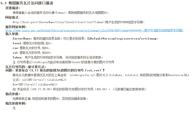
详情:请见四川地理信息中心网站。
2) 代码实现
继承API可的TiledMapServiceLayer类,派生SCTileMap子类,并对Initialize、GetTileUrl方法进行覆盖,后台具体代码及说明如下:
前台代码:
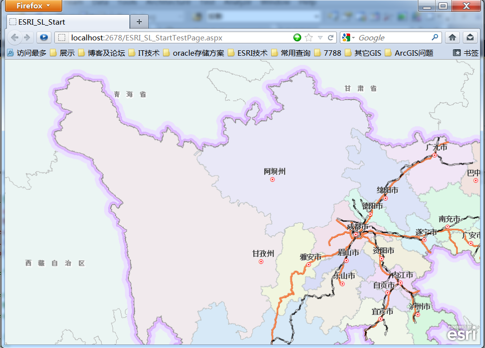
展现结果:
小结:
利用WebAPI进行相关切片读取比较简单,依照对Silverlight的实现可以进行Flex及Javascript的实现,关于针对搜索服务及网络服务的探讨将放在后续文章中给出。
文章来源:http://blog.csdn.net/esrichinacd/article/details/7595290
下面是四川地理信息中心能提供的一些服务,从类型上来讲包括切片、搜索及网络分析,均采用Rest组织风格。
下面针对切片的相关规则及代码实现给个具体的实现方法:
1) 规则说明
详情:请见四川地理信息中心网站。
2) 代码实现
继承API可的TiledMapServiceLayer类,派生SCTileMap子类,并对Initialize、GetTileUrl方法进行覆盖,后台具体代码及说明如下:
public classSCTileMap : TiledMapServiceLayer

    {

        privateconststringbaseUrl = "http://www.scgis.net.cn/iMap/i ... 3B%3B


        //System.Randomra = new System.Random();

        privateconstint WKID= 4326;

        //privateconst double baseScale = 3.38E-9 * 2.663;

        privateconstdoublebaseScale = 4622333.68;

        privatestring tokenStr ="";

        publicSCTileMap()

        {

            //进行页面请求

            requestGetToken();

        }

        public void requestGetToken()

        {

            stringurl = "http://www.scgis.net.cn/imap/i ... 3B%3B

            WebClientclient = new WebClient();

            client.DownloadStringCompleted +=ClientDownloadStringCompleted;

            client.DownloadStringAsync(newUri(url, UriKind.Absolute));

        }

        privatevoid ClientDownloadStringCompleted(object sender,DownloadStringCompletedEventArgse)

        {

            stringresult = e.Result;

            tokenStr = result.Split(newchar[] { '{' })[2].Split(newchar[] {'\"'})[3];


            setMetaData();

        }

        public override voidInitialize()

        {

        }

        privatevoid setMetaData()

        {

            //图层的全图范围

            this.FullExtent= new ESRI.ArcGIS.Client.Geometry.Envelope(95.918, 24.898, 110.14, 35.209)

            {

                SpatialReference = new ESRI.ArcGIS.Client.Geometry.SpatialReference(4326)

            };


            //图层的空间参考

            this.SpatialReference=new ESRI.ArcGIS.Client.Geometry.SpatialReference(4326);


            //设置切片的信息.每个切片的大小512x512px, 14级

            this.TileInfo= new TileInfo()

            {

                Height = 256,

                Width = 256,

                Origin = new ESRI.ArcGIS.Client.Geometry.MapPoint(-180, 90) { SpatialReference =new ESRI.ArcGIS.Client.Geometry.SpatialReference(4326) },

                Lods = newESRI.ArcGIS.Client.Lod[11]

            };


            //设置每一级别的分辨率.每一级别的分辨率都是前一个级别的一半

            doubleresolution = 0.010998662747496;

            for(int i = 0; i < TileInfo.Lods.Length; i++)

            {

                TileInfo.Lods[i] = newLod() {Resolution = resolution };

                resolution /= 2;

            }


            //调用初始化事件

            base.Initialize();

        }


         //返回指定切片的url

        public override stringGetTileUrl(int level,introw, int col)

        {

            stringURL = baseUrl + (level + 1).ToString() +"/"+ row.ToString() + "/" +col.ToString() + "?token="+this.tokenStr;

            returnURL;

        }

    }
前台代码:
<!--超图本地离线切片读取-->

        <!--四川地理信息中心在线服务读取-->

        <esri:Map x:Name="MyMap">

            <esri:Map.Layers >

                <customTiled:SCTileMap ID="sccustommap" x:Name="sc_custommap"/>

            </esri:Map.Layers>

        </esri:Map>
展现结果:
小结:
利用WebAPI进行相关切片读取比较简单,依照对Silverlight的实现可以进行Flex及Javascript的实现,关于针对搜索服务及网络服务的探讨将放在后续文章中给出。
文章来源:http://blog.csdn.net/esrichinacd/article/details/7595290