ArcGIS API for JavaScript 4.2学习笔记[19] 搜索小部件——使用更多数据源
-
2017-06-20
这节的主体代码和上篇几乎一致,区别就在上篇提及的sources属性。
先看看结果:
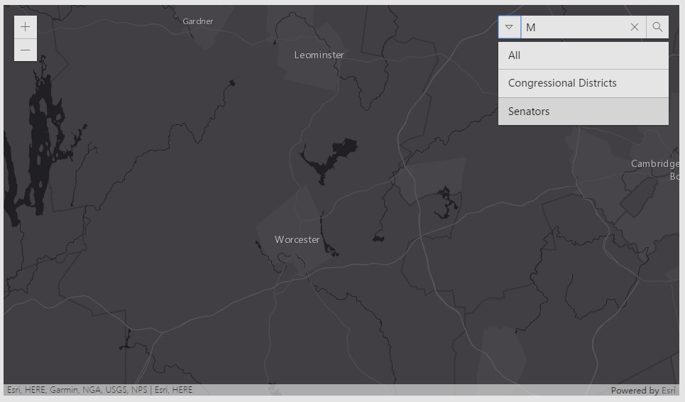
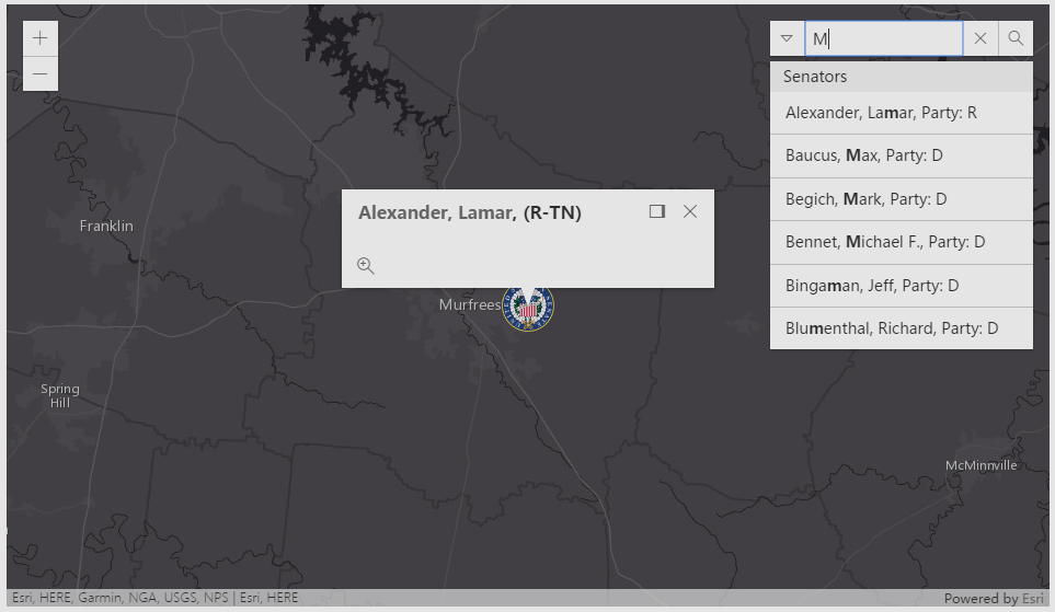
由于不太清楚要素图层里有什么东西,随便输了个字母匹配,结果如图,中央出现了一个图案并弹窗。
开始讲课!
给出引用
require(

    [

      "esri/Map",

      "esri/views/MapView",

      "esri/widgets/Search",

      "esri/layers/FeatureLayer",

      "esri/symbols/PictureMarkerSymbol",

      "dojo/domReady!"

    ],

    function(){}

);
PictureMarkerSymbol是上图中搜索结果的图案所需的模块。
可见此例子采用了要素图层来进行搜索。
函数参数骨架
function(Map, MapView, Search, FeatureLayer, PictureMarkerSymbol){

    var map = new Map({...});

    var view = new MapView({...});

    var searchWidget = new Search({

        ...

        sources: [{...},{...}]

    }

    view.ui.add(searchWidget, {...});

)
上一节提到Search这个类有一个重要的属性sources,它是Collection类型(同对象数组容器,与.NET中list容器差不多)。
看看完整代码:
sources: [{

  featureLayer: new FeatureLayer({

    url: "https://services.arcgis.com/V6 ... ot%3B,

    popupTemplate: {

      title: "Congressional District {DISTRICTID} </br>{NAME}, {PARTY}",

      overwriteActions: true

    }

  }),

  searchFields: ["DISTRICTID"],

  displayField: "DISTRICTID",

  exactMatch: false,

  outFields: ["DISTRICTID", "NAME", "PARTY"],

  name: "Congressional Districts",

  placeholder: "example: 3708",

}, {

  featureLayer: new FeatureLayer({

    url: "https://services.arcgis.com/V6 ... ot%3B,

    popupTemplate: {

      title: "<a href={Web_Page} target='_blank'> {Name}</a>, ({Party}-{State}) ",

      overwriteActions: true

    }

  }),

  searchFields: ["Name", "Party"],

  suggestionTemplate: "{Name}, Party: {Party}",

  exactMatch: false,

  outFields: ["*"],

  name: "Senators",

  zoomScale: 500000,

  resultSymbol: new PictureMarkerSymbol({

    url: "images/senate.png",

    height: 36,

    width: 36

  })

}]
我这里没有缩起来,原因就是已经很明显了——
sources给了一个Object数组,数组内有两个{}对象。
每个{}对象拥有以下属性:【featureLayer,searchFields,suggestionTemplate,exactMatch,outFields,name,zoomScale,resultSymbol】
查阅API,得知sources接受以下数据类型作为搜索源:
featureLayerSource
locatorSource
在上面,sources[{...},{...}]中的每个大括号对象就是featureLayerSource类型的。这里有点拗口,featureLayerSource和locatorSource不是js中的类,而是一种“说法”,因为sources接受的是Object数组作为参数,只不过本例以featureLayerSource作为示范而已。
【featureLayerSource】可选参数
displayField(String):用于显示结果的字段(名)
exactMatch(Boolean):是否精确搜索,默认是否(false)。
featureLayer(FeatureLayer):这个参数必须需要,因为是数据源啊。
searchFields(String):用于搜索的字段(名)。
searchQueryParams(Object):包括outSpatialReference、returnGeometry、num、outFields、where、maxAllowableOffset、objectIds
suggestQueryParams(Object):包括outSpatialReference、returnGeometry、num、outFields、where
以上两个Object类型的参数不知道是干嘛用的,前一个似乎是搜索时的默认选项,后一个是请求建议时的默认选项(与Search类的suggest()方法有关)?
suggestionTemplate(String):displayField有多个时,需要有格式地显示,就用这个。例子:suggestionTemplate: "Name: {OWNER}, Parcel: {PARCEL_ID}"
再看看locatorSource:
【locatorSource】可选参数
categories(String)
countryCode(String)
localSearchOptions(Object)
locationToAddressDistance(Number)
searchTemplate(String)
locator(Locator)
singleLineFieldName(String)
关于locatorSource就不说多了,这个数据源是对Locator(定位)类熟练运用才能使用的,因为前面的笔记没有对Locator有多余的描述,故仅仅在此记录。
回到sources[{...},{...}]的代码部分。
这样思路就清晰了,使用featureLayerSource作为搜索数据源,就要定义赋值上面提到的属性。
在featureLayer属性中,使用了popupTemplate方便输出。
在第二个featureLayerSource中,出现了一个新的东西——“resultSymbol”,它是PictureMarkerSymbol类的属性。查询API:
简单,这就是用一张图片指示出某个点。
这里用到了url、height、width三个属性,不必说多也知道是什么意思了。常用的属性还有xoffset、yoffset等。
总结一下。
如何在搜索小部件中使用多源数据呢?
只需要设置Search类的sources属性即可,可以有两种类型:featureLayerSource和locatorSource。
注意,虽然是这么说,但是写法上还是属于Object类型的。两个类型都需要设置必要的、可选的属性才能赋给sources属性。
最后给出完整的官方代码:
<!DOCTYPE html>

<html>

<head>

<meta charset="utf-8">

<meta name="viewport" content="initial-scale=1,maximum-scale=1,user-scalable=no">

<title>Search widget with multiple sources - 4.2</title>


<style>

html,

body,

#viewDiv {

padding: 0;

margin: 0;

height: 100%;

width: 100%;

}

</style>


<link rel="stylesheet" href="https://js.arcgis.com/4.2/esri ... gt%3B

<script src="https://js.arcgis.com/4.2/%26q ... gt%3B


<script>

require([

"esri/Map",

"esri/views/MapView",

"esri/widgets/Search",

"esri/layers/FeatureLayer",

"esri/symbols/PictureMarkerSymbol",

"dojo/domReady!"

], function(

Map,

MapView,

Search, FeatureLayer, PictureMarkerSymbol) {


var map = new Map({

basemap: "dark-gray"

});


var view = new MapView({

container: "viewDiv",

map: map,

center: [-97, 38], // lon, lat

scale: 10000000

});


var searchWidget = new Search({

view: view,

allPlaceholder: "District or Senator",

sources: [{

featureLayer: new FeatureLayer({

url: "https://services.arcgis.com/V6 ... ot%3B,

popupTemplate: { // autocasts as new popupTemplate()

title: "Congressional District {DISTRICTID} </br>{NAME}, {PARTY}",

overwriteActions: true

}

}),

searchFields: ["DISTRICTID"],

displayField: "DISTRICTID",

exactMatch: false,

outFields: ["DISTRICTID", "NAME", "PARTY"],

name: "Congressional Districts",

placeholder: "example: 3708",

}, {

featureLayer: new FeatureLayer({

url: "https://services.arcgis.com/V6 ... ot%3B,

popupTemplate: { // autocasts as new popupTemplate()

title: "<a href={Web_Page} target='_blank'> {Name}</a>, ({Party}-{State}) ",

overwriteActions: true

}

}),

searchFields: ["Name", "Party"],

suggestionTemplate: "{Name}, Party: {Party}",

exactMatch: false,

outFields: ["*"],

name: "Senators",

zoomScale: 500000,

resultSymbol: new PictureMarkerSymbol({

url: "images/senate.png",

height: 36,

width: 36

})

}]

});


// Add the search widget to the top left corner of the view

view.ui.add(searchWidget, {

position: "top-right"

});

});

</script>

</head>


<body></body>

</html> 源代码
注意与html同级别下有一个image文件夹,里面存有senate.png图片文件。
文章来源:http://www.cnblogs.com/onsummer/p/6421459.html